

Bennetts Close, Padbury
Bennetts Close is a strategic residential land project on the edge of Padbury in north Buckinghamshire. Cohanim's role has extended from development feasibility and masterplanning through Local Plan promotion, planning strategy, consultant procurement, deliverability evidence and the longer-term strategy for disposal to a housebuilder. The site has been actively promoted for residential development and was submitted to Buckinghamshire Council's Call for Sites in April 2025, supported by an indicative masterplan and vision document prepared as part of that process. The emerging Local Plan has subsequently identified the land as a proposed allocation for 25 dwellings, with no site-specific Key Development Requirements presently identified. The project is now being progressed towards an outline planning application designed to establish the principle of development and access while retaining sufficient flexibility for the eventual delivery partner.
Turning privately held land into a deliverable development opportunity The brief was not simply to prepare a housing layout. The objective was to determine whether land adjoining the existing settlement could become a credible residential development site, establish the most appropriate route through the planning system and progressively increase planning certainty without requiring the landowner to incur the cost of designing a scheme which a future housebuilder might subsequently replace. Our early work therefore considered planning prospects, density, access, development value, affordable housing, infrastructure, environmental constraints and the likely requirements of both Buckinghamshire Council and the eventual housebuilding market. The resulting strategy has been deliberately staged: understand the site → demonstrate capacity → promote the land → secure policy support → establish the principle through outline planning → bring a de-risked opportunity to the market.
Establishing development potential without over-designing the land Strategic land projects require a different approach from conventional architectural commissions. Too little information and the authority cannot be confident that development is deliverable. Too much design too early can create unnecessary cost, constrain a future housebuilder and introduce planning risks around details which do not need to be determined at outline stage. The challenge at Padbury has therefore been to produce enough architectural and technical evidence to demonstrate that the land can genuinely accommodate the emerging allocation while deliberately retaining flexibility over the eventual architecture. That principle ultimately led to an outline planning strategy with appearance and other detailed matters reserved, while access is proposed to be determined at outline stage.
A contained extension to the village
The allocation site extends to approximately 0.89 hectares and is held in a single private freehold ownership. There are no ransom strips or third-party land requirements. The land benefits from an existing vehicular access onto Bennetts Close which is within the landowner's control, allowing the development strategy to progress without land assembly. The physical constraints include: – A protected tree towards the north-east – A drainage ditch and watercourse along the eastern boundary – Mature hedgerow and tree belt along the southern boundary – Overhead electricity infrastructure in the vicinity – Public Footpath No.10 along the western edge Rather than treating these as residual areas after housing had been positioned, the evolving masterplan has used them to establish the landscape and movement structure of the development.
Promoting the land through the plan-making process
The land has been actively promoted for residential development since 2023. A significant step was the April 2025 Call for Sites submission, where the planning proposition was supported by an architectural vision and indicative masterplan demonstrating how residential development could be accommodated appropriately on the site. This moved the work beyond speculative land promotion. It gave Buckinghamshire Council a spatial basis on which to assess access, relationship with the village, landscape structure and realistic development capacity. Further planning work continued as the new Buckinghamshire Local Plan evolved.
From a line on a map to a deliverable allocation
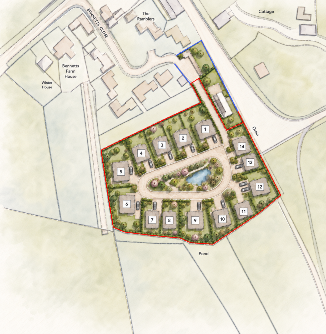
Local Plan allocation is only valuable if the land can actually be delivered. The architectural role has therefore been to test the Council's emerging capacity against the physical realities of the site. By August 2026, updated indicative masterplanning demonstrated that 25 dwellings could be accommodated while simultaneously: – Retaining the protected tree within an open setting – Maintaining the southern hedgerow and tree belt with a landscape buffer – Preserving an undeveloped corridor alongside the eastern watercourse – Retaining the public footpath on its existing alignment – Providing policy-compliant parking – Incorporating sustainable drainage – Allowing for the current policy assumption of 25% affordable housing The result is important because the allocation is supported by an actual development exercise rather than an assumed housing number applied to a site area.
Proposed for 25 homes under Policy SMA001
The most significant planning milestone to date came through Buckinghamshire's emerging Local Plan. The site is now identified as a proposed allocation for 25 dwellings under Policy SMA001. The planning advice received at the time also confirmed that no specific Key Development Requirements had been identified for the allocation. The Council's subsequent formal deliverability process records: – Allocation reference: 3352 – Site: Land off 7 Bennetts Close, Padbury – Capacity: 25 dwellings – Expected delivery: all 25 homes within the first five years following adoption In August 2026 Buckinghamshire Council approached the landowner for a formal Site Deliverability Form for submission to the Planning Inspectorate as part of the Regulation 19 Local Plan process. Cohanim coordinated and completed the development information supporting that submission on behalf of the landowner. This is described here as a proposed Local Plan allocation, rather than an adopted allocation, pending examination and adoption.
Designing enough to prove the principle
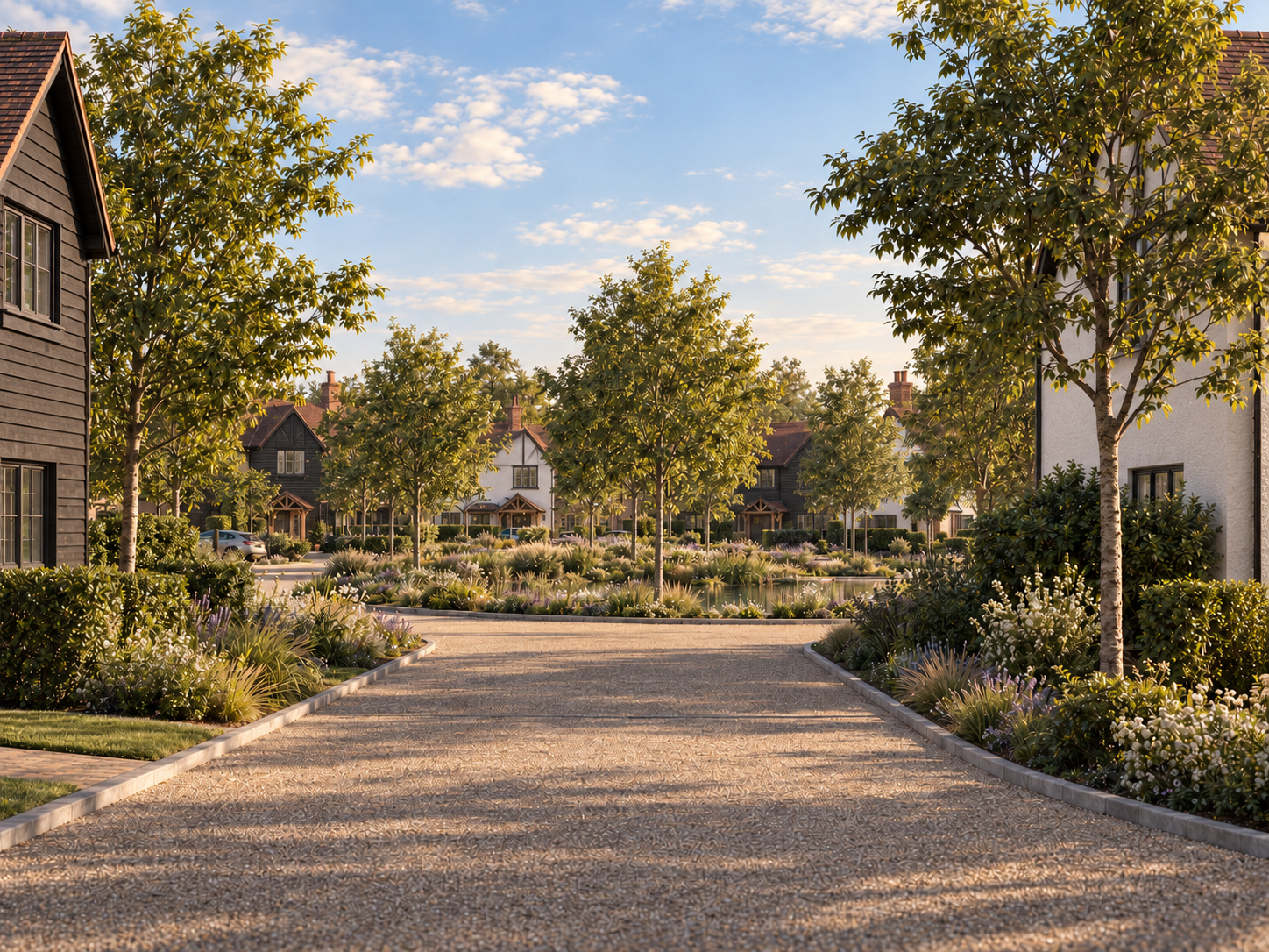
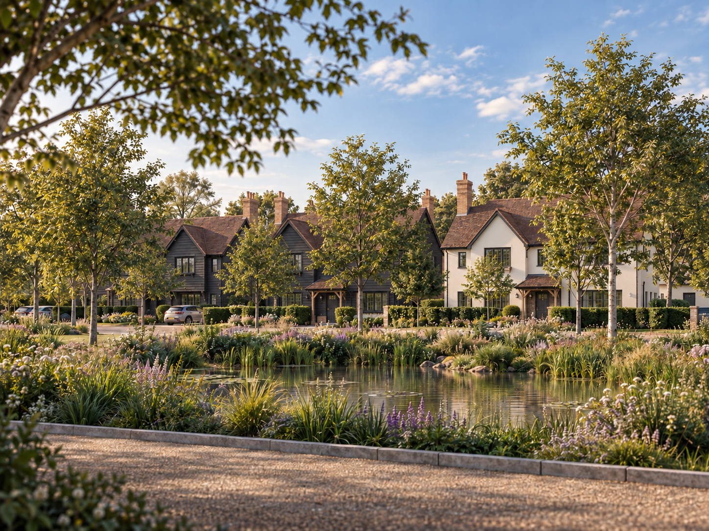
The masterplan has deliberately evolved alongside the planning strategy. Its role is not presently to dictate the final appearance of 25 houses. Instead, it tests the issues which determine whether the allocation is genuinely capable of being delivered: – Development capacity – Access and internal movement – Relationship with existing houses – Landscape buffers – Public-right-of-way retention – Drainage – Protected trees – Parking – Affordable housing – Open space – The relationship between built development and the village edge This allows architecture to provide confidence in the allocation without unnecessarily fixing details that are better developed with the future housebuilder.
Establishing the part of the scheme that cannot be left unresolved
The site benefits from an existing vehicular access onto Bennetts Close. Because access is fundamental to demonstrating deliverability, this is the one planning matter which is intended not to be reserved. The emerging outline application will therefore establish the access arrangement with Buckinghamshire's Highway Authority while allowing detailed layout, appearance, landscaping and other matters to be developed subsequently. Transport consultancy and access design form part of the technical team being assembled for the application.
Letting existing landscape structure organise the scheme
The site contains a number of environmental constraints, but current assessment has not identified any which prevent residential development. The protected tree can remain as a positive landscape feature. The southern hedgerow and mature tree belt establish a natural edge to the development. The watercourse creates an undeveloped eastern corridor, while the existing footpath provides a basis for pedestrian movement and landscape integration through the site. The technical programme includes a Preliminary Ecological Appraisal, UK Habitat Survey, protected-species work where required and a formal Biodiversity Net Gain assessment and metric. The intention is therefore not to clear the land into a blank development parcel, but to use its existing landscape structure as the framework around which the new neighbourhood is formed.
Building water management into the masterplan
The eastern boundary contains an existing ditch and watercourse. Surface water is proposed to be managed within the development through sustainable drainage and attenuated to greenfield run-off rates before discharge to the existing watercourse, subject to agreement with the Lead Local Flood Authority. The masterplan has already been tested to ensure that on-site SuDS can be accommodated alongside the proposed housing capacity rather than being treated as an engineering exercise to be fitted into residual space at a later stage.
Removing planning uncertainty before submission
The outline application is being supported by a coordinated programme of specialist work. The current technical scope includes: – Topographical survey - to establish levels, boundaries and existing features – Ecology and BNG - including habitat assessment and seasonal species surveys where triggered – Arboriculture - including BS5837 survey and impact assessment – Flood risk and drainage - including the surface-water and SuDS strategy – Transport and access - to establish an acceptable connection to Bennetts Close – Heritage - to assess the relationship with listed buildings and the historic village – Archaeology - through desk-based assessment – Ground conditions - through Phase 1 contamination and ground-risk assessment No technical work undertaken to date has identified a matter considered capable of preventing or materially delaying delivery.
Securing certainty without burdening the eventual developer
An outline application was selected deliberately. A full application would require substantial expenditure on detailed house design and could leave a purchaser with an approved architecture which does not correspond with its own product, construction system or market requirements. Planning in Principle, meanwhile, was not considered suitable for the scale of development being pursued. The outline route provides the balance required: establish the principle, access and development parameters, but allow the eventual housebuilder to control the detailed architecture through Reserved Matters. That reduces the landowner's exposure while creating a substantially more de-risked asset for disposal.
Designing for the planning system and the housebuilding market
The intended strategy is not for the existing landowner to self-build the development. Following outline planning permission, the site is intended to be marketed to a delivery partner. At approximately 25 homes, it is considered particularly suited to a single regional or SME housebuilder, and the absence of identified site-specific Key Development Requirements improves the simplicity of that proposition. This informs the architectural strategy. The masterplan needs to demonstrate a high-quality and credible form of development, but should not constrain the commercial flexibility required by the eventual purchaser. Cohanim's role therefore extends beyond securing planning permission into preparing the land to become an intelligible, technically supported and marketable development opportunity.
A site capable of coming forward early
The site is available immediately, held by a willing landowner and requires no third-party land or strategic infrastructure to be delivered. Utilities are available in the vicinity and no significant off-site enabling works have currently been identified. The deliverability programme submitted during the Local Plan process anticipates: – Pre-application engagement – Completion of technical and seasonal surveys – Outline planning submission – Determination – Marketing to a housebuilder – Reserved Matters and condition discharge – Subsequent construction The current Local Plan evidence anticipates all 25 dwellings being capable of delivery within the first five years following adoption.
From strategic promotion towards outline planning
Bennetts Close has now moved beyond the initial question of whether the land has development potential. The emerging Local Plan proposes the site for 25 dwellings. An updated masterplan has demonstrated that this capacity can be accommodated alongside the principal landscape, drainage, access, parking and affordable-housing requirements. Formal deliverability information has been provided to Buckinghamshire Council for the Regulation 19 / Planning Inspectorate process. The next stage is the preparation of the technical evidence and pre-application work required to support the outline planning application. The current programme anticipates outline submission in 2027, followed by disposal of the consented development opportunity to a housebuilder.
What the project has delivered so far
Chronological summary
| Date | Matter | Achievement |
|---|---|---|
| 2023 onwards | Strategic land promotion | Site actively promoted for residential development |
| 2024–25 | Feasibility and masterplanning | Development capacity, access, value, planning strategy and site constraints assessed |
| Apr 2025 | Buckinghamshire Call for Sites | Land formally promoted with an indicative masterplan and vision document |
| 2025 | Masterplan development | Alternative development arrangements tested against landscape, access and village-edge considerations |
| Mar 2026 | Development strategy | Outline planning identified as preferred route to establish planning certainty while retaining detailed flexibility for a future housebuilder |
| 2026 | Consultant strategy | Transport, arboriculture, archaeology, heritage, drainage/FRA, BNG, ecology and visual-impact requirements identified as part of the application programme |
| Jul 2026 | Emerging Local Plan | Site confirmed as proposed allocation for 25 dwellings through Policy SMA001, with no identified Key Development Requirements |
| Aug 2026 | Updated masterplanning | 25-home capacity tested successfully alongside TPO tree retention, landscape buffers, watercourse corridor, public footpath, SuDS, parking and affordable housing |
| Aug 2026 | Regulation 19 process | Buckinghamshire Council requested formal allocation deliverability evidence for submission to the Planning Inspectorate |
| Aug–Sep 2026 | Site Deliverability Form | Cohanim coordinated the updated delivery evidence on behalf of the landowner |
| 2026–27 | Pre-application preparation | Access and multidisciplinary technical information being developed for engagement with Buckinghamshire Council |
| 2027 – programmed | Outline planning | Outline application intended with all matters reserved except access |
| 2028 – programmed | Partnership | JV Opportunities explored in response to practical delivery |
| 2028–29 – programmed | Reserved Matters | Detailed design and pre-commencement condition process anticipated with delivery partner |
| 2029 onwards – programmed | Construction | Current Local Plan evidence anticipates commencement and first completions, with all 25 homes deliverable within the first five years after plan adoption |